Summary: Sherlock Holmes needs no Nanotyrannus natural history illustrations to note a fossilized juvenile in Elementary series' Dead Clade Walking Jan. 30, 2014.
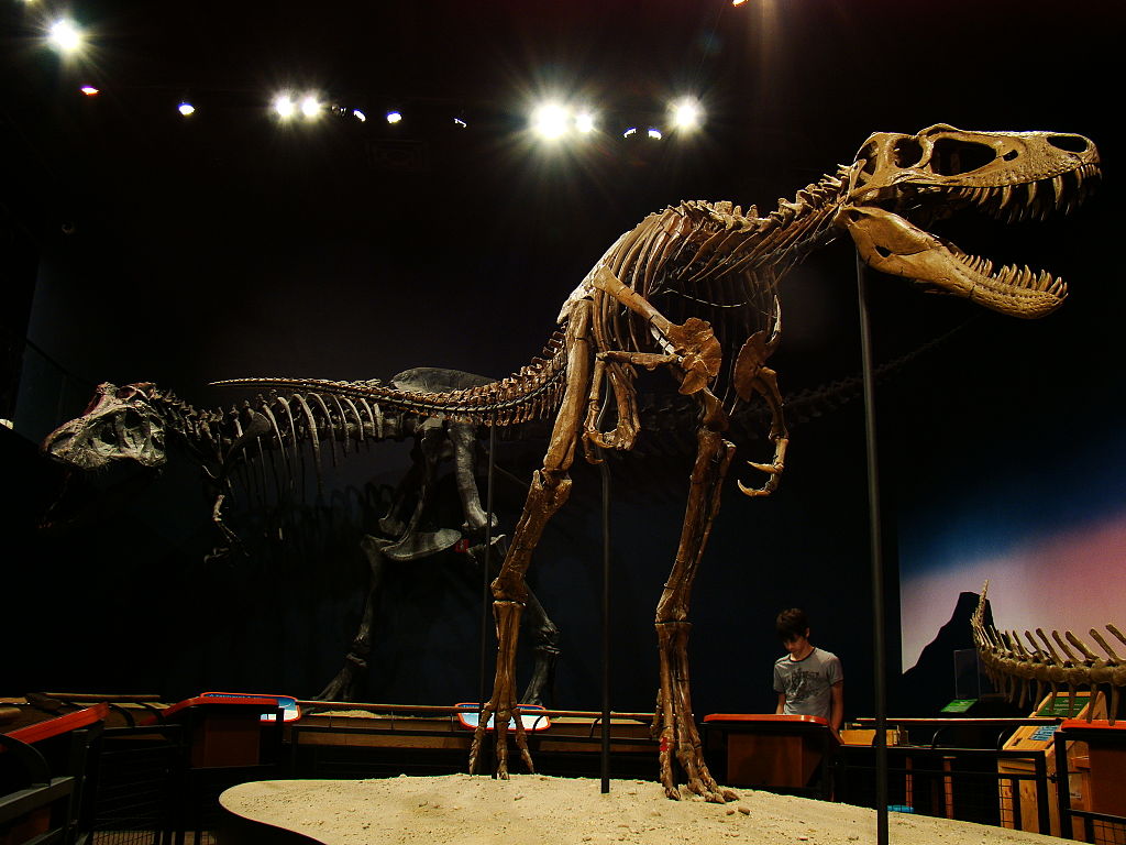 |
| "Jane," now generally thought to be a juvenile Tyrannosaurus rex rather than dubious new species Tyrannosaurus (Gorogsaurus lancensis), at the Burpee Museum of Natural History, Rockford, Winnebago County, north central Illinois; July 18, 2010: Volkan Yuksel, CC BY SA 3.0, via Wikimedia Commons |
A first and second, third and fourth appear in Nanotyrannus natural history illustrations, for a private collection and in the Columbia Broadcasting System's Elementary series episode Dead Clade Walking Jan. 30, 2014.
Director Helen Shaver and writers Robert Doherty and Jeffrey Paul King bring a fictitious fourth Nanotyrannus specimen into Elementary's 38th episode, as Season Two's 14th episode. The fictitious fourth compares and contrasts with Nanotyrannus natural history illustrations in clustering the most complete skeletons ever collected and in claiming controversial calculations and classifications. Deliberate deaths of Doug Newberg and Malcolm Turner and a destroyed fossil drive Sherlock Holmes (Jonny Lee Miller) toward a debunker (Jonno Roberts) of post-extinction dinosaurs.
Jaws, skull and two near-complete skeletons evidenced in subsequent Nanotyrannus natural history illustrations encourage elevation by experts to a new genus or new or established species.
David Hosbrook Dunkle (Sep. 9, 1911-Jan. 3, 1984) from Winnipeg, Manitoba, Canada, found the first fossil in the Lance Formation, Carter County, southeasternmost Montana, in 1942.
The Dunkle curatorship of vertebrate paleontology at the Cleveland Museum of Natural History (CMNH) in Ohio, 1939-1946, gave the jaws and skull the moniker CMNH 7541. The "nearly complete skull with tightly articulated lower jaws" headed Charles Whitney Gilmore (March 11, 1874-Sep. 27, 1945) toward species outside their genus's Belly River habitats. The United States National Museum curator of vertebrate paleontology at the present-day National Museum of Natural History in Washington, D.C., identified CMNH 7541 Sep. 12, 1946.
The scientific classification Gorgosaurus lancensis ("terrible lizard [from the] Lance [Formation]) juggled Gorgosaurus-like muzzles and teeth with "smaller size, elongate shallow maxillary, and rounder orbital fenestra."
Paleontologists kept Gorgosaurus lancensis until Aug. 15, 1988, when Robert T. Bakker, Philip Currie and Michael E. Williams (Aug. 4, 1940-July 12, 2003) kindled other taxonomies.
The University of Colorado-Boulder paleontology adjunct curator, the CMNH curator and the Tyrell Museum for Paleontology collections and research assistant director in Alberta, Canada, looked elsewhere. Forward-facing eyes, head "bent down sharply on the neck," mature-sutured skull and temporal region four times the muzzle's width moved the trio away from gorgosaur species. The three paleontologists named the "more primitive" relative of narrow-muzzled, stereoscopic vision-adapted, wide-fronted Tyrannosaurus rex ("tyrant lizard king") Nanotyrannus lancensis ("pygmy tyrant [from the] Lance [Formation]").
Thomas D. Carr of Carthage College's Biology Department in Kenosha, Wisconsin, offered the taxonomic option of "young T. rex" with "immature bone grain" Sep. 14, 1999.
A large-footed, long-legged, 21.32-foot- (6.5-meter-) long, 1,408.75- to 2,797.66-pound (639- to 1,269-kilogram) skeleton from the Hell Creek Formation, Garfield County, central-southeastern Montana, provided proof in 2001.
The 11-year-old queues up the names BMRP 2002.4.1 and Jane (Walrath Solem, Nov. 25, 1919-July 30, 2015) at Illinois's Burpee Museum of Natural History in Rockford. Hell Creek Formation's "Bloody Mary" renders Bakker, Black Hills Institute paleontologist Peter Larson, CK Preparations preparator Chris Morrow and dinosaur-prospecting rancher Clayton Phipps unpersuaded since 2006. Bloody Mary and Jane, with CMNH 7541-like skulls, respectively suggest separate-species adulthood with arms and claws twice those of Tyrannosaurus rex and same-species, sleek-bodied, thin-toothed youth.
Rare metal-free rock, not Nanotyrannus natural history illustrations, tell Sherlock of "a miniature T. rex" from above the dinosaur-extinction, K-T (Cretaceous-Tertiary) Boundary 65.5 million years ago.
 |
| A package left at the front stoop of Sherlock Holmes' (Jonny Lee Miller) contains the remains of a Nanotyrannus, smuggled from Mongolia into the United States, in Elementary tv series' Dead Clade Walking (season 2 episode 14): Elementary @ElementaryCBS via Twitter Jan. 27, 2014 |
Acknowledgment
My special thanks to talented artists and photographers/concerned organizations who make their fine images available on the internet.
Image credits:
Image credits:
"Jane," now generally thought to be a juvenile Tyrannosaurus rex rather than dubious new species Tyrannosaurus (Gorogsaurus lancensis), at the Burpee Museum of Natural History, Rockford, Winnebago County, north central Illinois; July 18, 2010: Volkan Yuksel, CC BY SA 3.0, via Wikimedia Commons @ https://commons.wikimedia.org/wiki/File:T-rex_fossil_Jane_by_Volkan_Yuksel_DSC08683g.JPG
A package left at the front stoop of Sherlock Holmes' (Jonny Lee Miller) contains the remains of a Nanotyrannus, smuggled from Mongolia into the United States, in Elementary tv series' Dead Clade Walking (season 2 episode 14): Elementary @ElementaryCBS via Twitter Jan. 27, 2014, @ https://www.facebook.com/ElementaryCBS/photos/a.151627898295663.14686.151013691690417/303915126400272/
For further information:
For further information:
Bakker, Robert T.; Michael Williams; and Philip Currie. 1988. "Nanotyrannus, a New Genus of Pygmy Tyrannosaur, From the Latest Cretaceous of Montana." Hunteria, vol. 1, no. 5 (Aug. 15, 1988): 1-30. Boulder CO: University of Colorado Museum.
Available via Zenobo @ https://zenodo.org/record/1037529#.WwL-lUgvyUk
Available via Zenobo @ https://zenodo.org/record/1037529#.WwL-lUgvyUk
Carr, T. (Thomas) D. 1999. "Craniofacial Ontogeny Tyrannosauridae (Dinosauria, Coelurosauria)." Journal of Vertebrae Paleontology, vol. 19, no. 3 (Sept. 14, 1999): 497-520. doi:10.1080/02724634.1999.10011161. Norman OK: University of Oklahoma.
Available via ResearchGate @ https://www.researchgate.net/publication/254313764_Craniofacial_ontogeny_in_Tyrannosauridae_Dinosauria_Coelurosauria
Available via ResearchGate @ https://www.researchgate.net/publication/254313764_Craniofacial_ontogeny_in_Tyrannosauridae_Dinosauria_Coelurosauria
"Dead Clade Walking." Elementary: The Second Season. Los Angeles CA: Paramount Pictures Corporation, Jan. 30, 2014.
Doyle, Sir Arthur Conan. The Adventures of Sherlock Holmes. London England: George Newnes Ltd., 1892.
Elementary @ElementaryCBS. 27 January 2014. "Added a new photo." Twitter.
Available @ https://www.facebook.com/ElementaryCBS/photos/a.151627898295663.14686.151013691690417/303915126400272/
Available @ https://www.facebook.com/ElementaryCBS/photos/a.151627898295663.14686.151013691690417/303915126400272/
Gilmore, Charles W. 12 September 1946. "A New Carnivorous Dinosaur From the Lance Formation of Montana." Smithsonian Micellaneous Collections, vol. 106, no. 13 (Publication 3857): 1-19. Washington DC: Smithsonian Institution, Sept. 12, 1946.
Available @ https://biodiversitylibrary.org/page/27394614
Available @ https://biodiversitylibrary.org/page/27394614
Joyce, Laurel. 30 May 1988. "Paleontologists' Fieldwork by Phone Identifies 'The Cleveland Critter.'" The Scientist > May 1988 Issue > News.
Available @ https://www.the-scientist.com/?articles.view/articleNo/9519/title/Paleontologists--Fieldwork-By-Phone-Identifies--The-Cleveland-Critter-/
Available @ https://www.the-scientist.com/?articles.view/articleNo/9519/title/Paleontologists--Fieldwork-By-Phone-Identifies--The-Cleveland-Critter-/
Lucy Liu @LucyLiu. 30 January 2014. "Aanother guest on tonight's dead clade walking episode. this one was a real diva #elementary." Twitter.
Available @ https://twitter.com/LucyLiu/status/429110951208439808
Available @ https://twitter.com/LucyLiu/status/429110951208439808
Marriner, Derdriu. 13 December 2013. “Fruit in Osage Orange Botanical Illustrations and Elementary Series.” Earth and Space News. Friday.
Available @ https://earth-and-space-news.blogspot.com/2013/12/fruit-in-osage-orange-botanical.html
Available @ https://earth-and-space-news.blogspot.com/2013/12/fruit-in-osage-orange-botanical.html
Marriner, Derdriu. 22 November 2013. “George Stubbs Painting The Godolphin Arabian and Elementary's Nutmeg.” Earth and Space News. Friday.
Available @ https://earth-and-space-news.blogspot.com/2013/11/george-stubbs-painting-godolphin.html
Available @ https://earth-and-space-news.blogspot.com/2013/11/george-stubbs-painting-godolphin.html
Marriner, Derdriu. 15 November 2013. “John Wootton Painting The Darley Arabian and Elementary's Studhorse.” Earth and Space News. Friday.
Available @ https://earth-and-space-news.blogspot.com/2013/11/john-wootton-painting-darley-arabian.html
Available @ https://earth-and-space-news.blogspot.com/2013/11/john-wootton-painting-darley-arabian.html
Marriner, Derdriu. 8 November 2013. “John Wootton Painting The Byerley Turk and Elementary's Thoroughbreds.” Earth and Space News. Friday.
Available @ https://earth-and-space-news.blogspot.com/2013/11/john-wootton-painting-byerley-turk-and.html
Available @ https://earth-and-space-news.blogspot.com/2013/11/john-wootton-painting-byerley-turk-and.html
Marriner, Derdriu. 30 August 2013. “Turner Fighting Temeraire Painting in Elementary Series Episode The Woman.” Earth and Space News. Friday.
Available @ https://earth-and-space-news.blogspot.com/2013/08/turner-fighting-temeraire-painting-in.html
Available @ https://earth-and-space-news.blogspot.com/2013/08/turner-fighting-temeraire-painting-in.html
Marriner, Derdriu. 7 June 2013. “Paul Gauguin Painting Tahitian Women on the Beach in Elementary's The Woman.” Earth and Space News. Friday.
Available @ https://earth-and-space-news.blogspot.com/2013/06/paul-gauguin-painting-tahitian-women-on.html
Available @ https://earth-and-space-news.blogspot.com/2013/06/paul-gauguin-painting-tahitian-women-on.html
Marriner, Derdriu. 31 May 2013. “Rubens Painting The Incredulity of St Thomas in Elementary's The Woman.” Earth and Space News. Friday.
Available @ https://earth-and-space-news.blogspot.com/2013/05/rubens-painting-incredulity-of-st.html
Available @ https://earth-and-space-news.blogspot.com/2013/05/rubens-painting-incredulity-of-st.html
Marriner, Derdriu. 24 May 2013. “Henri de Toulouse-Lautrec Painting Rousse in Elementary Episode The Woman.” Earth and Space News. Friday.
Available @ https://earth-and-space-news.blogspot.com/2013/05/henri-de-toulouse-lautrec-painting.html
Available @ https://earth-and-space-news.blogspot.com/2013/05/henri-de-toulouse-lautrec-painting.html
Marriner, Derdriu. 17 May 2013. “The Bruegel Painted Parable in the Elementary Series Episode The Woman.” Earth and Space News. Friday.
Available @ https://earth-and-space-news.blogspot.com/2013/05/the-bruegel-painted-parable-in.html
Available @ https://earth-and-space-news.blogspot.com/2013/05/the-bruegel-painted-parable-in.html
Marriner, Derdriu. 22 February 2013. “Osmia Avosetta Natural History Illustrations for Elementary's Bee.” Earth and Space News. Friday.
Available @ https://earth-and-space-news.blogspot.com/2013/02/osmia-avosetta-natural-history.html
Available @ https://earth-and-space-news.blogspot.com/2013/02/osmia-avosetta-natural-history.html
Marriner, Derdriu. 1 February 2013. “Russian Tortoise Natural History Illustrations and Elementary's Clyde Jan. 31, 2013.” Earth and Space News. Friday.
Available @ https://earth-and-space-news.blogspot.com/2013/02/russian-tortoise-natural-history.html
Available @ https://earth-and-space-news.blogspot.com/2013/02/russian-tortoise-natural-history.html
Marriner, Derdriu. 25 January 2013. “Costliest, World-Most Expensive Chopard Watch: 201 Carats at $25 Million.” Earth and Space News. Friday.
Available @ https://earth-and-space-news.blogspot.com/2013/01/costliest-world-most-expensive-chopard.html
Available @ https://earth-and-space-news.blogspot.com/2013/01/costliest-world-most-expensive-chopard.html
Marriner, Derdriu. 18 January 2013. “Chopard Watch Worth $25 Million on Elementary Episode The Leviathan.” Earth and Space News. Friday.
Available @ https://earth-and-space-news.blogspot.com/2013/01/chopard-watch-worth-25-million-on.html
Available @ https://earth-and-space-news.blogspot.com/2013/01/chopard-watch-worth-25-million-on.html
Marriner, Derdriu. 11 January 2013. “Claude Monet Painting Nympheas 1918 in Elementary Series' Leviathan.” Earth and Space News. Friday.
Available @ https://earth-and-space-news.blogspot.com/2013/01/claude-monet-painting-nympheas-1918-in.html
Available @ https://earth-and-space-news.blogspot.com/2013/01/claude-monet-painting-nympheas-1918-in.html
Marriner, Derdriu. 4 January 2013. “Paul Cézanne Still Life Painting Fruit in Elementary Series' Leviathan.” Earth and Space News. Friday.
Available @ https://earth-and-space-news.blogspot.com/2013/01/paul-cezanne-still-life-painting-fruit.html
Available @ https://earth-and-space-news.blogspot.com/2013/01/paul-cezanne-still-life-painting-fruit.html
Marriner, Derdriu. 28 December 2012. “Paul Signac Painting Women at the Well in Elementary Series' Leviathan.” Earth and Space News. Friday.
Available @ https://earth-and-space-news.blogspot.com/2012/12/paul-signac-painting-women-at-well-in.html
Available @ https://earth-and-space-news.blogspot.com/2012/12/paul-signac-painting-women-at-well-in.html
Marriner, Derdriu. 21 December 2012. “The Van Gogh Pietà Painting in Elementary Series Episode The Leviathan.” Earth and Space News. Friday.
Available @ https://earth-and-space-news.blogspot.com/2012/12/the-van-gogh-pieta-painting-in.html
Available @ https://earth-and-space-news.blogspot.com/2012/12/the-van-gogh-pieta-painting-in.html
Marriner, Derdriu. 14 December 2012. “Edward Hopper Painting Western Motel in Elementary Series' Leviathan.” Earth and Space News. Friday.
Available @ https://earth-and-space-news.blogspot.com/2012/12/edward-hopper-painting-western-motel-in.html
Available @ https://earth-and-space-news.blogspot.com/2012/12/edward-hopper-painting-western-motel-in.html
Marriner, Derdriu. 29 September 2012. "Are Lesser Clovers Sherlock's Lucky Shamrocks on Elementary's Pilot?" Earth and Space News. Friday.
Available @ https://earth-and-space-news.blogspot.com/2012/09/are-lesser-clovers-sherlocks-lucky.html
Available @ https://earth-and-space-news.blogspot.com/2012/09/are-lesser-clovers-sherlocks-lucky.html
Parrish, J.M. (Michael); M. (Michael) Henderson; P. (Philip) J. Currie; and E. (Eva) Koppelhus, eds. 2013. Origin, Systematics, and Paleobiology of the Tyrannosauridae. Dekalb IL: Northern Illinois University Press.
Sloan, Christopher. 2013. Tracking Tyrannosaurs: Meet T. rex's Fascinating Family, From Tiny Terrors to Feathered Giants. Washington, D.C.: National Geographic Children's Books.