Summary: Cape Henry Lighthouse is U.S.'s first lighthouse and first publish works project as a new nation. Lit from 1792 to 1881, it still stands on Chesapeake Bay.
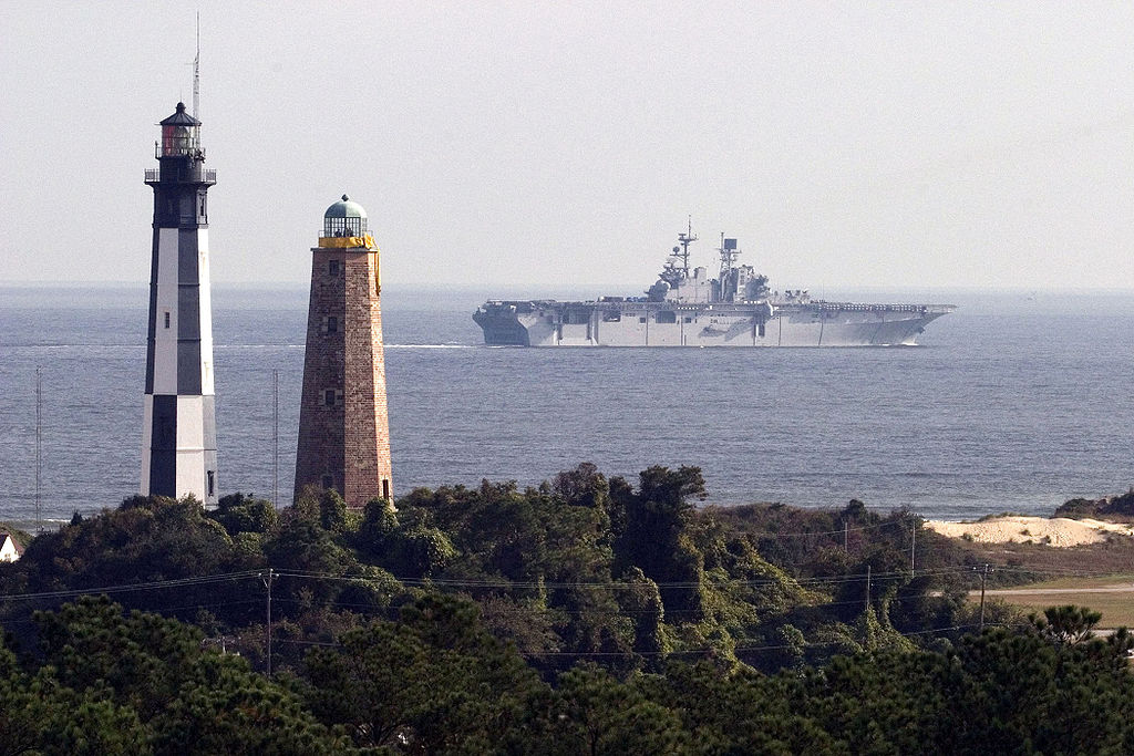 |
| Cape Henry Lighthouses, older (right) and modern replacement (left), overlook amphibious assault ship USS Bataan’s passage to Atlantic Ocean: United States Navy/Photographer’s Mate 1st Class Ken Riley, Public Domain, via Wikimedia Commons |
Cape Henry marks the southern side of the entrance to the Chesapeake Bay, a large, Atlantic Ocean estuary on the North American coast. Cape Charles defines the northern side of the entrance to the partly enclosed, inland body of brackish water.
Known as the Virginia Capes, the two headlands were named for the two sons of James I (June 19, 1566–March 27, 1625), King of England and Ireland (March 24, 1603–March 27, 1625) during the North American expeditions of the Virginia Company (April 10, 1606–May 24, 1624).
Cape Henry honors elder son Henry Frederick, Prince of Wales (Feb. 19, 1594–Nov. 6, 1612).
Cape Charles honors younger son Charles (Nov. 19, 1600–Jan. 30, 1649), Duke of Albany and, later, King Charles I of England and Ireland (March 27, 1625–Jan. 30, 1649).
The Cape Henry Lighthouse holds the honor of being the first lighthouse built under the authority of the newly formed nation of the United States of America.
The Act for the Establishment and Support of Lighthouses, Beacons, Buoys, and Public Piers was approved Friday, Aug. 7, 1789, as the ninth piece of official legislation passed by the First United States Congress, which met from March 4, 1789, to March 4, 1791.
The Act has landmark status as the first public works act passed by Congress. Included in the Act is specific mention of the construction of the Cape Henry Lighthouse:
“Sec. 2. And be further enacted, That a lighthouse shall be erected near the entrance of the Chesapeake Bay, at such place, when ceded to the United States in manner aforesaid, as the President of the United States shall direct.” (Chapter IX)
“Sec. 2. And be further enacted, That a lighthouse shall be erected near the entrance of the Chesapeake Bay, at such place, when ceded to the United States in manner aforesaid, as the President of the United States shall direct.” (Chapter IX)
By November 1789, the Virginia General Assembly ceded land at the tip of Cape Henry in Princess Anne County (now the independent city of Virginia Beach). The site stands less than one-quarter of a mile (0.32 kilometers) from the First Landing, the point where Captain Christopher Newport (Dec. 29, 1561–Aug. 15, 1617) and Virginia Company colonists landed April 26, 1607. The landing preceded establishing England’s first permanent American settlement on May 4, 1607, at Jamestowne, to the north on the James River, Virginia’s largest Chesapeake Bay tributary.
Secretary of the Treasury Alexander Hamilton (Jan. 11, 1755/1757–July 12, 1804) selected New York City architect John McComb Jr. (1763–1853) as designer for the new nation’s first lighthouse.
McComb’s final plans included revised foundation depth from 13 feet (3.96 meters) to 20 feet (6.09 meters) below sea level as well as increased base diameter from 27 feet 6 inches (8.38 meters) to 33 feet (10.05 meters).
With a thickness of 11 feet (3.35 meters), the exterior wall presents a circular design for the first 4 feet (1.2 meters), then rising for 93 feet (28.3 meters) as an octagonal truncated pyramid to the 13-foot (3.96 meters), fish oil-fueled lantern tower.
Building materials, for which the architect was responsible contractually, utilized Aquia sandstone that had been brought over from Brooks Quarry on the Rappahannock River for an earlier, failed attempted at lighthouse construction by the royal colonies of Maryland and Virginia.
Final cost of $17,700 ($425,000-plus in 2015) ran $2,500 ($60,000-plus in 2015) over the project’s first estimate.
Cape Henry Lighthouse was first lit in October 1792 by its third keeper, Laban Goffigan. The first keeper, William Lewis, died within a month of his appointment. The second keeper, Lemuel Cornick, abandoned his post after less than a year.
Subsequent renovation projects included lantern improvements in 1841 and repairs by 1863 from Confederate damage during the War Between the States (April 12, 1861–April 9, 1865). The original wooden access was replaced with a cast iron staircase in 1867.
Cape Henry Lighthouse was last lit Dec. 15, 1881, by its last keeper, photographer Jay Dearborn Edwards (1831-1900), who then lit the new, adjacent Cape Henry Lighthouse as its first keeper. Large cracks in six of the old lighthouse's eight faces, detected during a routine inspection in 1872, had necessitated construction of a replacement 350 feet (106.68 meters) to the southeast.
In 1914, the lighthouses were encompassed within military land with the installation of Fort Story, which became Joint Expeditionary Base (JEB) Little Creek-Fort Story via transfer Oct. 1, 2009, to the United States Navy.
On June 18, 1930, Congress deeded the original lighthouse and 1.77 acres to Preservation Virginia.
The lighthouse's significance is recognized through enlistment as: National Historic Landmark in 1972; National Register of Historic Places on Oct. 15, 1966; and Virginia Landmarks Register on Sept. 9, 1969.
The old lighthouse visibly stands sentinel with its cast iron replacement.
Under Preservation Virginia’s ownership, Cape Henry Lighthouse is open to the public. With entrance to the historic lighthouse by way of JEB security gates, valid identification is required.
Exuding the sweep of history of a young nation and offering vibrant panoramas, Old Cape Henry Lighthouse is a must-see landmark, especially for history, lighthouse and maritime enthusiasts.
Visitor information: Hours
January 3 to March 15: 10:00 a.m.–4:00 p.m.;
March 17 to October 31: 10:00 a.m.–5:00 p.m.;
November 1 to December 30: 10:00 a.m.–4:00 p.m.
closed: Virginia Beach’s Shamrock Marathon (St. Patrick Day weekend), Thanksgiving, Christmas Eve and Day, New Year’s Eve and Day, January 2.
temperature/weather closures: When tower's inside temperature registers 105° F. (40.55° C.) or during inclement weather, including lightning and thunderstorms.
Contact details:
URL: http://preservationvirginia.org/visit/historic-properties/cape-henry-lighthouse
address: 583 Atlantic Ave, Fort Story, Virginia 23459
telephone: (757) 422-9421
 |
| aerial view, facing east-southeast, of Cape Henry, with both lighthouses (upper left): Gabor Eszes (UED77), CC BY SA 3.0, via Wikimedia Commons |
Acknowledgment
My special thanks to talented artists and photographers/concerned organizations who make their fine images available on the internet.
Image credits:
Image credits:
Cape Henry Lighthouses, older (right) and modern replacement (left), overlook amphibious assault ship USS Bataan’s passage to Atlantic Ocean: United States Navy/Photographer’s Mate 1st Class Ken Riley, Public Domain, via Wikimedia Commons @ https://commons.wikimedia.org/wiki/File:Fort_Story_lighthouses.jpg
aerial view of Cape Henry with both lighthouses: Gabor Eszes (UED77), CC BY SA 3.0, via Wikimedia Commons @ https://commons.wikimedia.org/wiki/File:CapeHenry.jpg
For further information:
For further information:
"History of the Lighthouse." Preservation Virginia > Visit > Cape Henry Lighthouse.
Available @ http://preservationvirginia.org/visit/property-detail/history-of-cape-henry-lighthouse
Available @ http://preservationvirginia.org/visit/property-detail/history-of-cape-henry-lighthouse
Jones, Ray. The Lighthouse Encyclopedia: The Definitive Reference. Guilford CT: Globe Pequot Press, 2013.
Marriner, Derdriu. "New Cape Henry Lighthouse: Tallest United States Cast Iron Lighthouse." Earth and Space News. Tuesday, Sept. 1, 2015.
Available @ https://earth-and-space-news.blogspot.com/2015/09/new-cape-henry-lighthouse-tallest.html
Available @ https://earth-and-space-news.blogspot.com/2015/09/new-cape-henry-lighthouse-tallest.html